
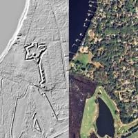

Charleston is surrounded by the remains of more than 300 years of military history—much of it hidden beneath forests, neighborhoods, fields, and marshes.
In this LiDAR America video, we explore more than 30 historic forts, batteries, redoubts, defensive lines, and military sites throughout the Charleston, South Carolina area. The sites span from the colonial and Revolutionary War periods through the Civil War and into the coastal-defense era of the 20th century.
Using LiDAR imagery, we can strip away vegetation visually and reveal surviving earthworks and changes in the landscape that can be extremely difficult—or impossible—to recognize from conventional aerial imagery.
SITES FEATURED IN THIS VIDEO
CSA Fort Bull (1863–1865) — West Charleston
CSA/Union Black Island Battery (1863–1865) — Black Island
CSA Redoubts No. 3, No. 5 & No. 6 (1861–1862) — James Island
CSA Fort Trenholm (1864–1865) — Johns Island
CSA Battery Cheves (1863–1865) — James Island
CSA Fort Pickens (1861–1862) — Charleston County
CSA Battery Wilkes (1863–1865) — West Charleston
CSA Fort Pemberton (1862–1865) — James Island
Fort Sumter (1829–1865; 1874–1947) — Charleston
Fort Moultrie (1809–1947), Battery Jasper (1898–1942), Battery Logan (1899–1944) & Battery Capron (1898–1942) — Sullivan’s Island
CSA Fort Palmetto (1863–1865) — Mount Pleasant
Shutes Folly Redoubt (1775) & Castle Pinckney (1809–1878; 1917–1924) — Shutes Folly Island
CSA Battery Magwood (1863–1865) — West Charleston
Charles Towne Landing (1670–1680) — West Charleston
Union Long Island Fort 1 (1863–1865) — Long Island
British Wappoo Creek Redoubt (1780) — West Charleston
CSA Church Flats Battery (1862–1863) — Charleston County
CSA Battery Tynes (1863–1865) — James Island
CSA Battery at Johns Island Ferry (1863–1865) — West Charleston
CSA Fort Pringle (1863–1865) — James Island
CSA Fort Pringle, CSA Battery Leroy & Beauregard’s New Line Battery No. 1 (1863–1865) — James Island
CSA Longbranch Creek Battery (1863–1865) — West Charleston
CSA Battery No. 5, Beauregard’s New Line (1863–1865) — James Island
CSA Fort Lamar (1862–1865) — James Island
CSA Bridge Neck Battery (1863–1865) — James Island
CSA Camp Secessionville (1863–1865) — James Island
Fort Johnson (1704–1880), Martello Tower (1815/1833) & British Siege Line (1780) — James Island
PLEASE NOTE: Some locations shown in this video are on private property or otherwise have restricted public access. Their inclusion is for historical, educational, and documentary purposes only and does not indicate that the sites are open to the public. Please respect all property boundaries, posted signs, protected archaeological resources, and applicable laws. Do not trespass or enter any site without the property owner’s permission.
LiDAR America uses publicly available remote-sensing imagery to explore archaeological, historical, and military landscapes across the United States.
LiDAR America — Uncovering America’s Hidden Landscapes
#LiDAR #Charleston #SouthCarolina #CivilWar #AmericanHistory #MilitaryHistory #HistoricForts #Archaeology